![]()

To see a list and map of all Voyage Communities, visit the Community Network main page.
Opening Date: September 4, 2024
Exhibition Type: Mark II (Generation 2 with customization upgrade)
Lead Institution: Delaware State University
Partner Institutions:
University of Delaware
NASA
Capital School District (Dover, DE)
Location: Delaware State University campus
Overview
Delaware State University (DSU) has partnered with the University of Delaware on the “Delaware Space Observation Center,” funded by Congressionally Directed Spending from the office of Senator Chris Coons and administered by NASA, making it possible for DSU to acquire the Voyage exhibition.
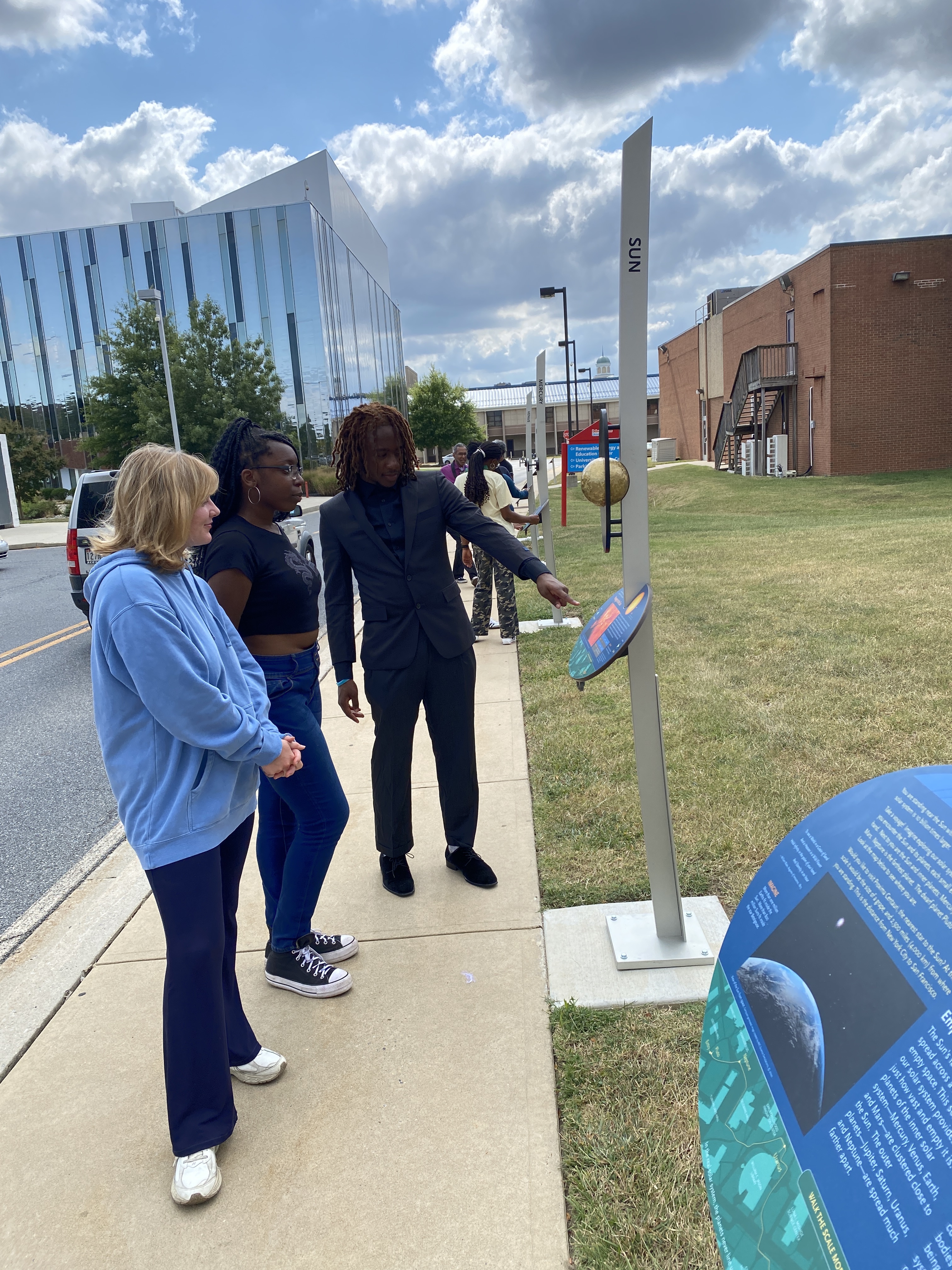
Click on Image to Zoom
As one of America’s Historically Black Colleges and Universities (HBCUs), DSU is a center of learning for students from many backgrounds, currently enrolling 62% African-American students and an increasing number of Caucasian, Hispanic, Asian, and other international students.
One of DSU’s strategic goals is to create an exceptional learning environment that promotes challenging, high-quality curricular and co-curricular programs, engaged student learning, and local and global citizenship. Our Voyage exhibition will greatly help achieve this goal by contributing to DSU’s intellectual climate and culture.
Another strategic goal is to strengthen and expand DSU’s outreach and engagement programs to benefit the people of Delaware, the nation, and the world. The Voyage exhibition will be an outreach focal point for both the local community and visitors from afar.
The Voyage exhibition at DSU will provide:
- an experiential learning opportunity for undergraduate non-science majors with direct and powerful connections to the space science curriculum;
- an educational opportunity for local school districts;
- an outreach opportunity to the community, where the campus can become a STEM education destination site for pre-college student groups, families and the public at large;
- a sculptural element to the campus experience for all visitors;
- Voyage tours led by undergraduate science and education majors and graduate students, serving as role models to pre-college students; and
- other opportunities leveraged by visits by outside groups, such as combining tours of the exhibition with:
- tours of research facilities;
- a presentation by a faculty researcher;
- an evening star party, with connections made between the Voyage planets and the planets visible in the night sky; and
- professional development for K-12 educators, allowing a campus visit to be embedded in a unit on Solar System exploration in the pre-college classroom.
DSU already has regular open houses at its observatory, and after installation of the Voyage exhibition, this open house can include a visit to — and tour of — the Voyage exhibition.
So, objectives include:
- providing visitors an understanding of Earth’s place in space;
- showing how a model can be a powerful learning tool;
- extending science education experiences to an outdoor space where science and sculpture combine synergistically; and
- using the exhibition as a focal point for programming that engages diverse audiences across a community with a largely underserved population.
Implementation Plan
The National Center for Earth and Space Science Education would like to encourage a community to not just install a Voyage exhibition as a passive experience, but proactively put Voyage to work, with e.g., tours, both guided and self-guided, and classroom-based pre- and post-tour lessons on Solar System science and exploration. The community’s lead organization, working in concert with the other partner organizations, submits an Implementation Plan where all collectively propose how the Voyage exhibition and associated educational materials would be used in their community to address the Voyage Key Objectives (see Section 1 here), hopefully in perpetuity.
Download Dover, DE, Implementation Plan
Site Maps
To explore the maps below at high resolution, first click on the map and wait for it to load as a pop-up window. If you see the icon ![]() in the upper right corner of the window, you can click on it and explore at higher resolution. Alternatively, you can drag the pop-up window to your desktop to download. Once downloaded, Zoom in to view at higher resolution.
in the upper right corner of the window, you can click on it and explore at higher resolution. Alternatively, you can drag the pop-up window to your desktop to download. Once downloaded, Zoom in to view at higher resolution.
Preliminary Site Maps: To help a community understand how the Voyage model Solar System will lay out at the proposed site, the National Center for Earth and Space Science Education generates Preliminary Site Maps (PSMs), which overlay the proposed position of the Sun and orbits of the planets atop Google Earth images. The radii of the orbits are the average distances of the planets from the Sun at the 1 to 10-billion scale. The PSMs provide an understanding of where the orbits intersect walking paths, so that positions of the exhibitions’s 13 stanchions can be identified.
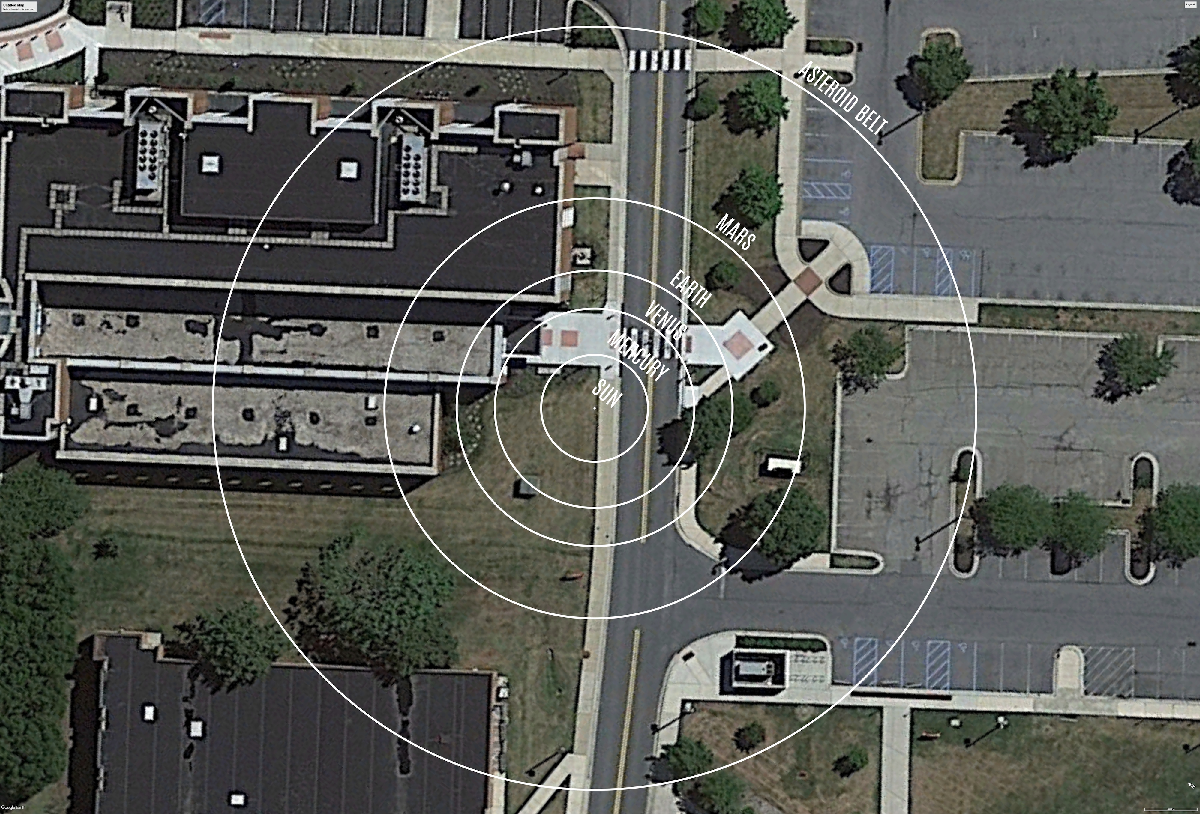
The Inner Solar System orbits out to the Asteroid Belt.
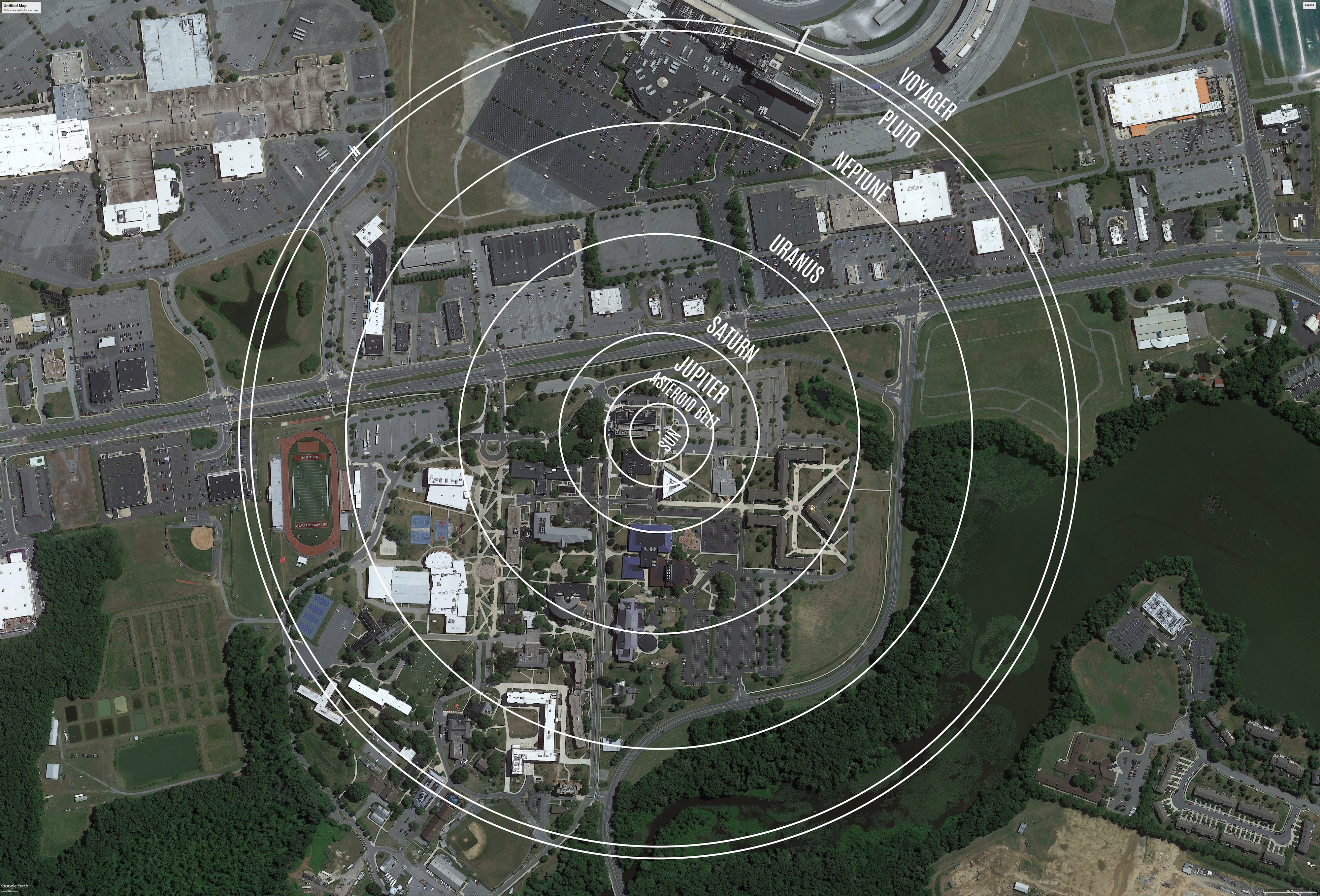
The Outer Solar System orbits from the Asteroid Belt out to Pluto.
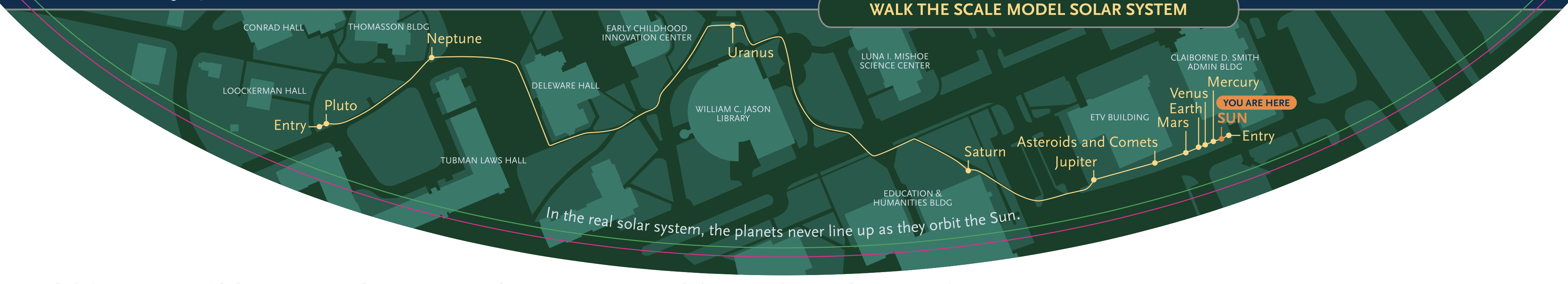
Formal Site Maps: A Formal Site Map (FSM) is produced by the community using a CAD map of the site (if available) that is accurate at sub-meter resolution. The FSM identifies the precise locations of the exhibition’s 13 stanchions relative to local buildings, streets, pathways, and green spaces.
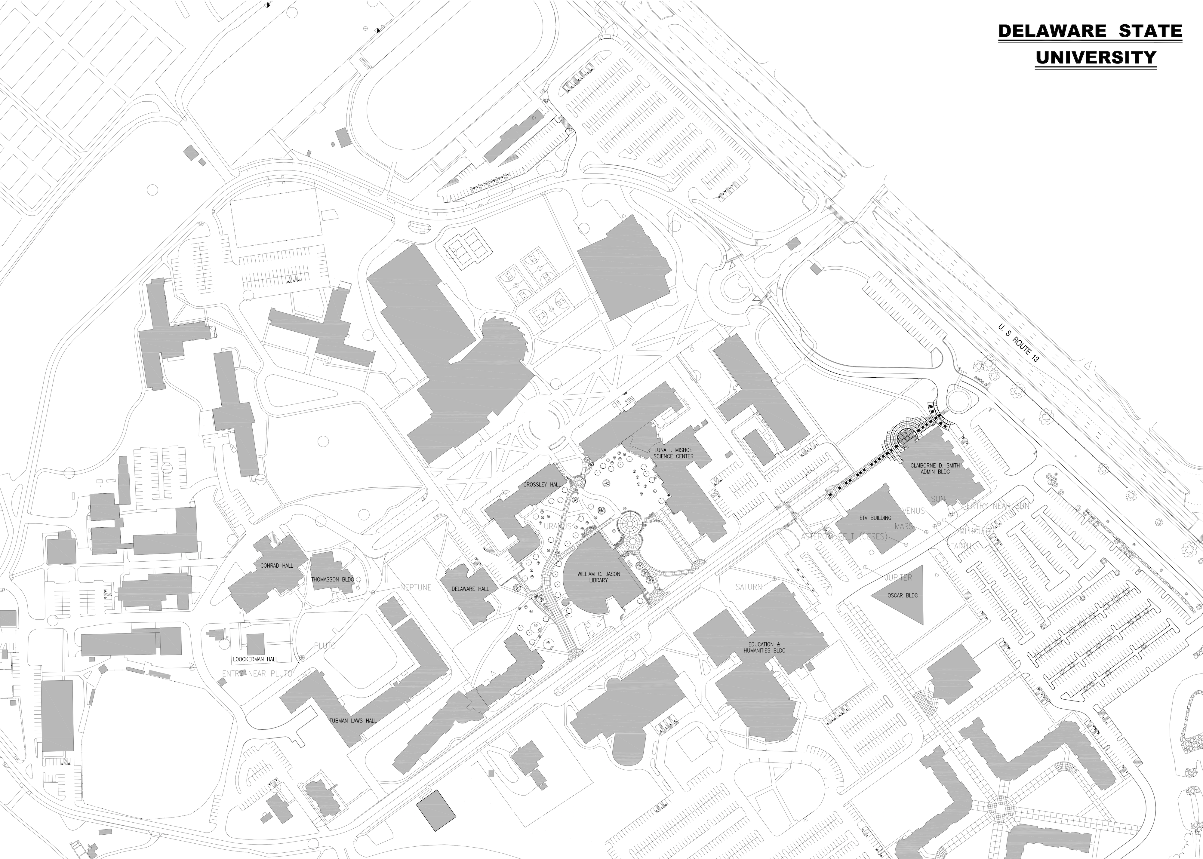
Custom Site Map: If a community has purchased a Customization Upgrade, each of the exhibition’s 13 storyboards includes a Custom Site Map (CSM) created by the designer for the Voyage National Program. The Formal Site Map provided by the community is used to create the CSM, which maintains the Voyage design aesthetic defined by style and color palette. The CSM provides the visitor with wayfinding information relative to local landmarks.