
To see a list and map of all Voyage Communities, visit the Community Network main page.
Opening Date: TBD
Exhibition Type: Mark II (Generation 1)
Lead Institution: Lake Area Technical College
Partner Institutions:
Mother of God Monastery
The Harmony Hill Watertown Project
City of Watertown
Watertown Development Company
Location: Harmony Hill, Watertown, South Dakota
Overview
Watertown, South Dakota is the state’s fifth largest city, offering many activities and historical sites without big-city crowds. Visitors can explore the history of this “coteau” region at attractions such as the first Governor of South Dakota’s home, the Mellette House, the Codington County Heritage Museum or the newly restored Goss Opera House in the historical downtown district. Many folks come to experience the wide open spaces of the prairie, the vast wildlife of the area and Americana Art by Terry Redlin at the Terry Redlin Art Center. Watertown is host to one of only two zoos in South Dakota, the Bramble Park Zoo, certainly a destination not to miss.
Watertown is also home to Lake Area Technical College (LATC), one of the Nation’s leading two-year technical colleges and a recipient of the Aspen Prize for Community College Excellence. LATC is known for its wide array of academic programs and focus on STEM education and careers.
Soon, the Watertown community will have an additional, unique feature: the Challenger Learning Center of South Dakota. The Learning Center will be built on the Harmony Hill Watertown campus. Harmony Hill Watertown is home to the Benedictine Sisters of Mother of God Monastery. This square mile is being developed into a synergistic, multifaceted, intergenerational community that will be the host site of the Challenger Learning Center of South Dakota and the 24 acre Challenger Park.
We envision the Voyage model Solar System to be a feature and a compliment to the Learning Center. As the primary feature of the park, Voyage will allow the theme ‘From the Prairie to the Stars’ to be made visible through the placement of the thirteen stanchions and accompanying trails. We want Voyage to provide educators and parents a tangible tool to discuss the vastness of our Solar System – something that is hard to do in the classroom and difficult for the developing student brain to visualize. Voyage will be an incredibly valuable teaching aid.
There are few things that can offer an experience of the enormity of space and our place in this magnificent universe. As the primary feature of Challenger Park, the Voyage Solar System will be such an experience as well as enhance this destination for tourists – adults and youngsters alike.
Implementation Plan
The National Center for Earth and Space Science Education would like to encourage a community to not just install a Voyage exhibition as a passive experience, but proactively put Voyage to work, with e.g., tours, both guided and self-guided, and classroom-based pre- and post-tour lessons on Solar System science and exploration. The community’s lead organization, working in concert with the other partner organizations, submits an Implementation Plan where all collectively propose how the Voyage exhibition and associated educational materials would be used in their community to address the Voyage Key Objectives (see Section 1 here), hopefully in perpetuity.
Download Watertown, SD, Implementation Plan
Site Maps
To explore the maps below at high resolution, first click on the map and wait for it to load as a pop-up window. If you see the icon ![]() in the upper right corner of the window, you can click on it and explore at higher resolution. Alternatively, you can drag the pop-up window to your desktop to download. Once downloaded, Zoom in to view at higher resolution.
in the upper right corner of the window, you can click on it and explore at higher resolution. Alternatively, you can drag the pop-up window to your desktop to download. Once downloaded, Zoom in to view at higher resolution.
Preliminary Site Maps: To help a community understand how the Voyage model Solar System will lay out at the proposed site, the National Center for Earth and Space Science Education generates Preliminary Site Maps (PSMs), which overlay the proposed position of the Sun and orbits of the planets atop Google Earth images. The radii of the orbits are the average distances of the planets from the Sun at the 1 to 10-billion scale. The PSMs provide an understanding of where the orbits intersect walking paths, so that positions of the exhibitions’s 13 stanchions can be identified.

The Inner Solar System orbits out to the Asteroid Belt.
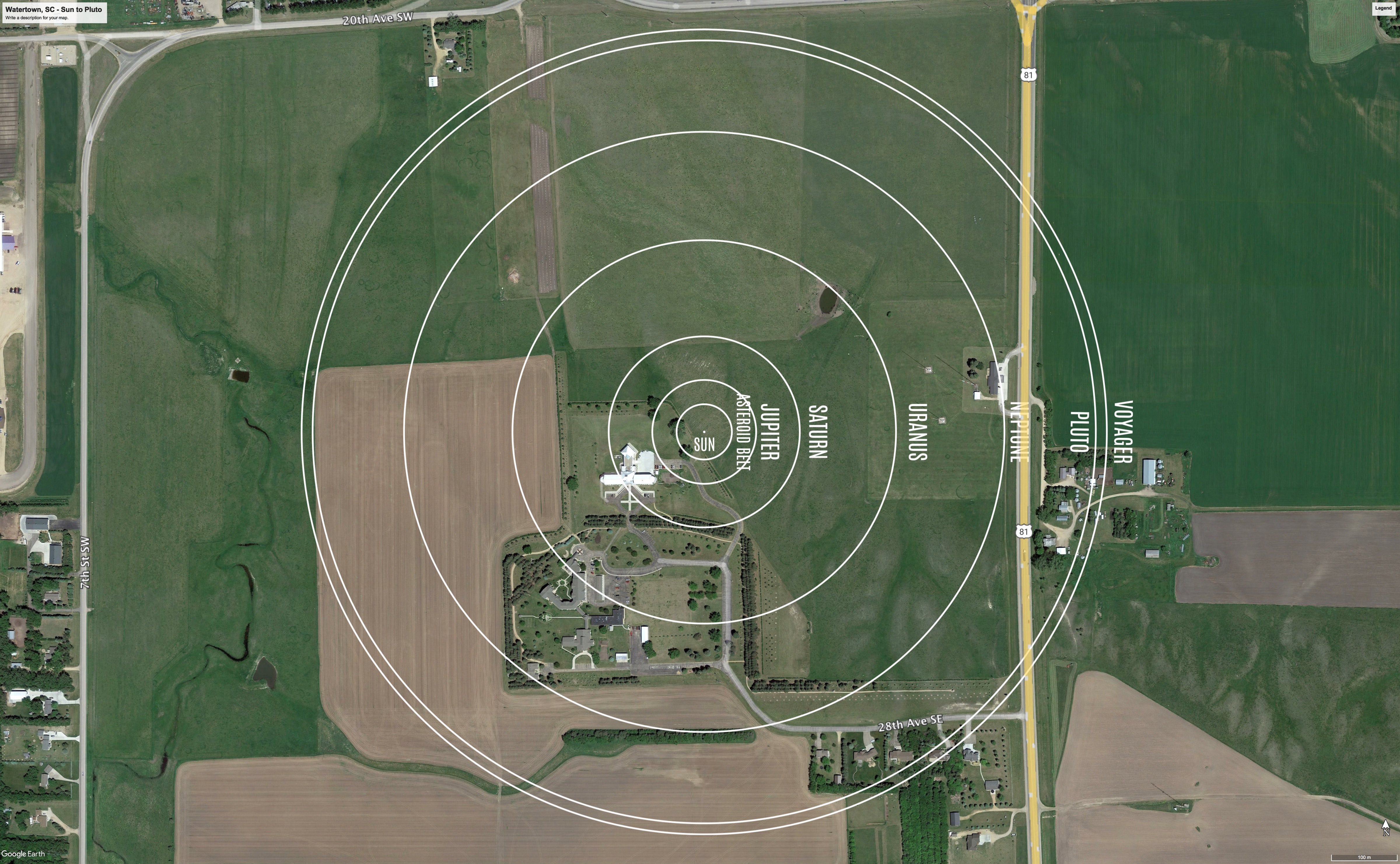
The Outer Solar System orbits from the Asteroid Belt out to Pluto.
Formal Site Map: A Formal Site Map (FSM) is produced by the community using a CAD map of the site (if available) that is accurate at sub-meter resolution. The FSM identifies the precise locations of the exhibition’s 13 stanchions relative to local buildings, streets, pathways, and green spaces.
Note: since the site is an undeveloped field, no CAD map is needed. The FSMs accepted by the National Center for Earth and Space Science Education are the PSMs above with locations identified for the stanchions.
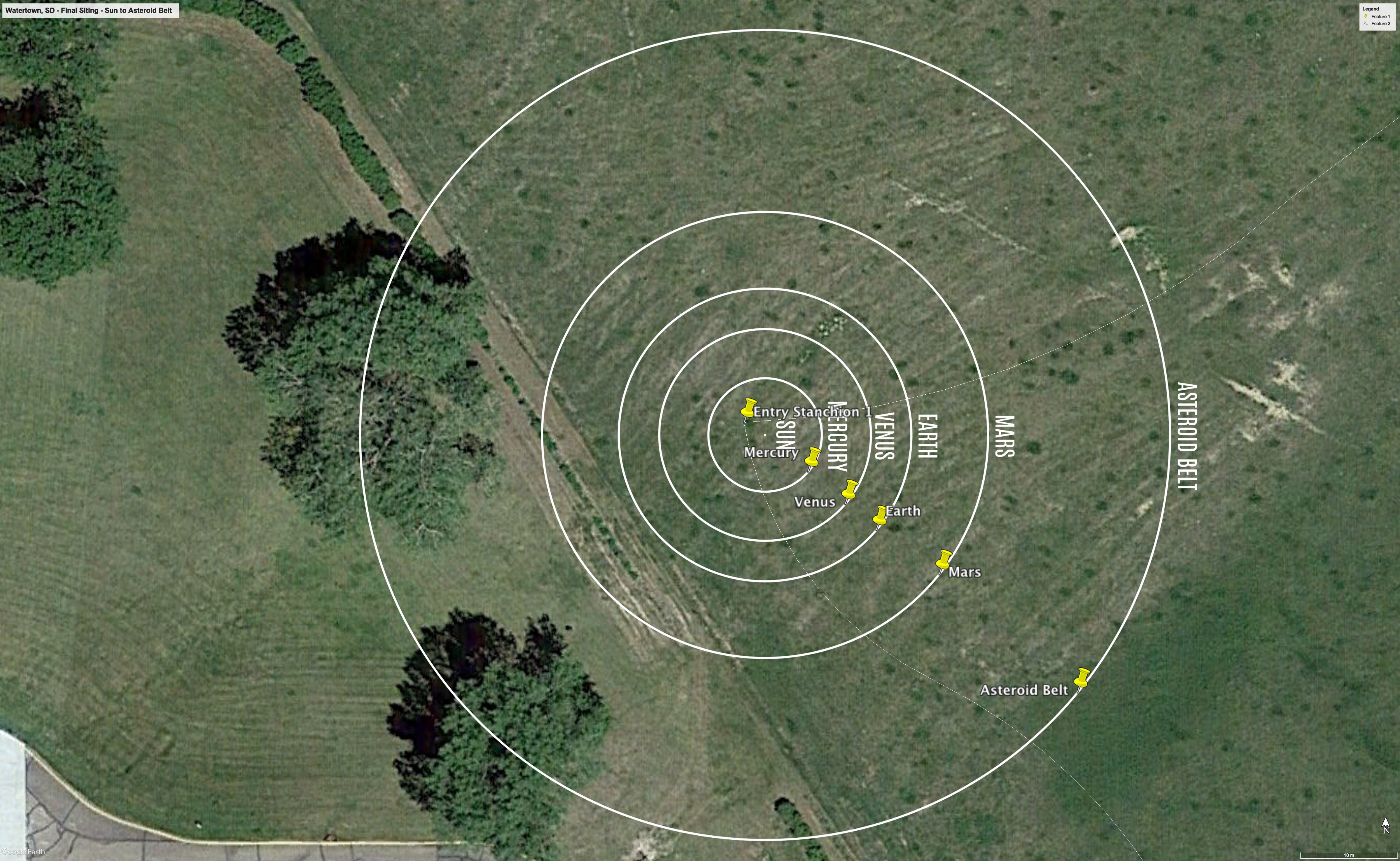
The Inner Solar System orbits out to the Asteroid Belt. The yellow push pins mark the future locations of the exhibition’s stanchions.
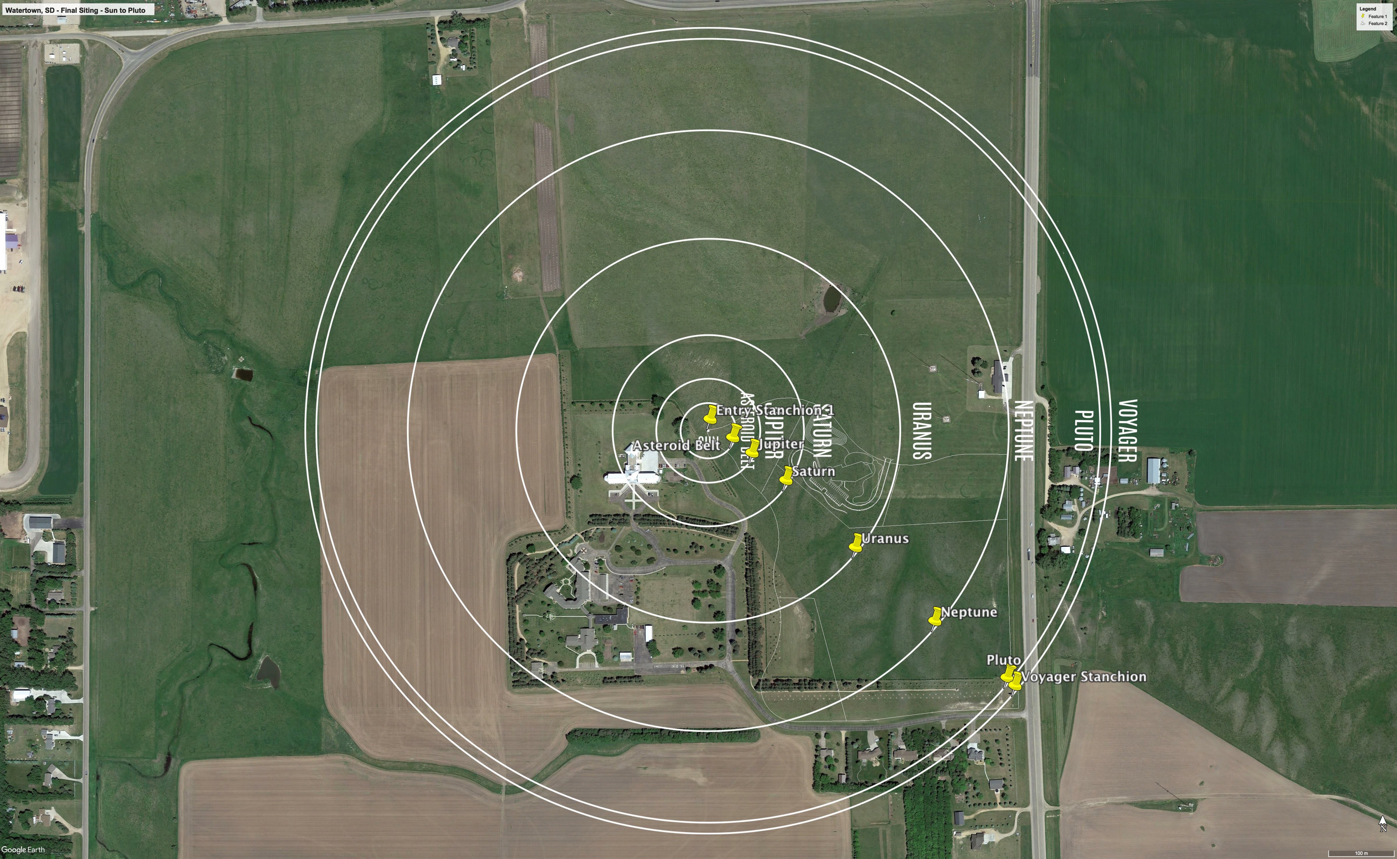
The Outer Solar System orbits from the Asteroid Belt out to Pluto. The yellow push pins mark the future locations of the exhibition’s stanchions.